Landslides
Landslides are part of a geologic process called "mass wasting," which is characterized by the downslope movement of material under the force of gravity. Conditions that precipitate landslides include:
- Saturation of soil and rock material with water
- Vibrations due to earthquakes or blasting
- Oversteepening of slopes by undercutting (removal of material through erosion or excavation)
- Oversteepening of slopes by addition of material (such as fill) on the upper portions of the slopes
- Alternating freezing and thawing
Additionally, removal of vegetation can leave a slope much more susceptible to surficial landslides because of the loss of the stabilizing root systems.
These conditions reduce a slope's resistance to sliding and/or increase the force contributing to slope movement. In the case of saturation, water effectively weakens the soil and rock by reducing cohesion and friction between particles. Cohesion, which is the tendency of soil particles to "stick" to each other, and friction affect the strength of the material in the slope and contribute to a slope's ability to resist downslope movement. Saturation also increases the weight of the slope materials and, like the addition of material on the upper portion of a slope, increases the gravitational force on the slope. Undercutting of a slope reduces the slope's resistance to the force of gravity by removing much-needed support at the base of the slope. Alternating cycles of freeze and thaw can result in a slow, virtually imperceptible loosening of rock, thereby weakening the rock and making it susceptible to slope failure.
Geologists identify active landslides and areas subject to slope instability so that they may be avoided or mitigated. Together, geologists and civil engineers develop and implement measures to improve the stability of slopes, repair existing landslides, and prevent damage from future landslides. Slope stability can be improved by removing material from the top of the slope, adding material or retaining structures to the base of the slope, and reducing the degree of saturation by improving drainage within the slope.
Chairs: James Arthurs
Types of Landslide
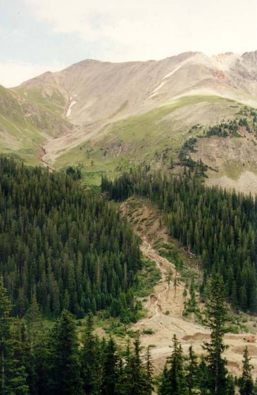
Debris Flows - a mixture of rock fragments, soil, vegetation, water and, in some cases, entrained air that flows downhill as a fluid. Debris flows can range in consistency from that of freshly mixed concrete to running water. Debris flows can be further classified as mudflows and earthflows depending on the ratio of water to soil and rock debris. Lahars are a special form of debris flow caused by volcanic eruptions.
|
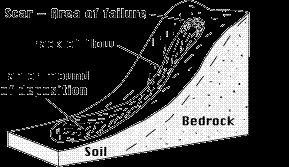
Above: Schematic of debris flow. Image courtesy of USGS.
Right: Photograph of Grizzly Peak, Colorado debris flow. Image courtesy of Colorado Department of Transportation.
|
 |
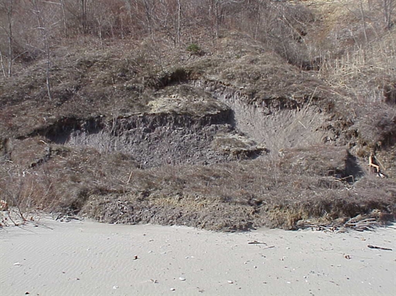
Slump - a landslide consisting of a mass of material moving downslope as a unit, usually along a curved plane of failure. The removed mass of soil and rock leave an abrupt drop-off at the top of the landslide known as a scarp. Repeated slumping can often result in terracing, or a series of scarps, as secondary failures occur within the landslide mass.
|
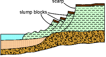
Above: Schematic of slump. Image courtesy of Maine Geological Survey.
Right: Photograph of slump failure in Wisconsin. Image courtesy of University of Wisconsin-Madison.
|
 |
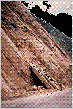
Rock Slide - the rapid movement of a large mass of rock along a plane of weakness, such as a bedding plane or joint. In general, rock slides occur on steep mountain faces but have been known to occur on slopes as low as 15 degrees.
|
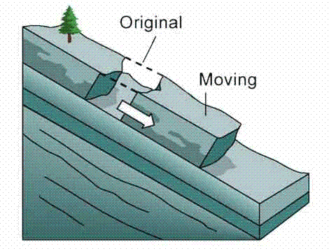
Above: Schematic of rock slide. Image courtesy of Geoscience Australia.
Right: Photograph of rock slide. Image courtesy of University Melbourne.
|
 |
Rock Fall - the freefall of rock from a cliff. Rock falls are often the result of physical weathering such as ice wedging. The rock typically accumulates at the base of the cliff in the form of talus (loose rock). Rock falls are often triggered by earthquakes.
|
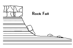
Above: Schematic of rock fall. Image courtesy of Utah Geological Survey.
Right: Photograph of rock fall from Kaibab Cliff near the Grand Canyon. Image courtesy of Mesa Community College.
|
.jpg) |
Historical Landslide Events
Numerous landslides across the world have been recorded throughout human history. Some notable recent landslide events include:
- Vaiont Dam, Italy, October 9, 1963: This landslide resulted in water overtopping the Vaiont Dam reservoir in northern Italy. Slope instability within the reservoir was observed as slow creep of 7 cm/week three years before the ultimate failure. Slow creep continued until September 1963, when the slope began to creep at 25 cm/day. On October 8, the creep rate increased to 40 cm/day. The next day approximately 240 million cubic meters of soil and rock slid down the hillside and entered the reservoir. This generated a wave of water 100 meters high that swept over the dam and into the valley. The subsequent surge resulted in the deaths of 2,600 people. It was later determined that the hillside failed due to a combination of geologic factors: 1) the bedrock consisted of a weak limestone with interbedded clay layers; 2) the bedding planes were dipping steeply toward the reservoir; and 3) the increased volume of water in the reservoir saturated the soil and rock, reducing the material cohesion (Hamblin and Christiansen, 1995). Check out the The Vaiont Landslide by Dr. David Petley for additional details.
- Nevado del Ruiz, Colombia, November 13, 1985: The eruption of the volcano Nevado del Ruiz melted ice and snow on the summit that mixed with ejected ash and rock. These materials formed lahars that flowed downslope via the Lagunillas and Azufrado Rivers. The two flows merged at the base of the mountain approximately 3 kilometers from the town of Amero, moving at a rate of 40 km/hr. As the lahar emerged from a narrow canyon it spread out over 40 square kilometers, overwhelming Amero with a 40-meter-high wall of mud and ash. The lahar resulted in the deaths of 22,000 people (Rahn, 1996). Visit the U.S. Geological Survey Volcano Hazards Website on Nevado del Ruiz for additional information and pictures.
- Gros Ventre, Wyoming, June 23, 1925: This landslide is an example of a slope failure along bedding planes (boundaries between sedimentary rock layers.) At this site, the Tensleep sandstone overlies the Amsden shale. Bedding within these shale and sandstone formations dips at approximately 20 degrees toward the Gros Ventre River. Deep erosion of the river bed had cut through the sandstone, leaving it supported only by friction with the underlying shale. Following a very wet winter, the sandstone slid along the shale bed and transported 38 million cubic meters of rock into the valley. The slide impounded the Gros Ventre River with a 68-meter-high dam of rock, creating the Lower Slide Lake (Easterbrook, 1999). Visit the Gros Ventre Slide for additional information on the slope failure.
Links to More Information
Technical References
Easterbrook, Don J., 1999, Surface Processes and Landforms: Prentice Hall, New Jersey, 2nd Ed., p. 70-71.
Hamblin, W.K. and E.H. Christiansen, 1995, Earth's Dynamic Systems: Prentice Hall, New Jersey, 7th Ed., p. 241-242.
Rahn, Perry H., 1996. Engineering Geology, An Environmental Approach: Prentice Hall, New Jersey, 2nd Ed., p. 202.
For more in-depth information about landslides, check out AEG's Technical References page.
COORDINATOR OF TECHNICAL WORKING GROUPS
The Immediate Past President is the Coordinator of Technical Working Groups and shall provide coordination among the Groups; liaison between the Groups and the Board; and distributing Association information to various Technical Working Group Chairs.
|